If you take any of the organized hikes in Hocking Hills State Park, the naturalists will tell you how Queer Creek got its name. Queer Creek is the major stream that runs through the park; it’s the one that goes over the falls at Cedar Falls. As you continue downstream, the Gorge Trail turns to the right to head up Old Man’s Creek to Old Man’s Cave, but Queer Creek itself continues ahead to where it joins Salt Creek. The creek near Ash Cave is not Queer Creek itself, but is the East Fork of Queer Creek (and on older maps it is called “Feed Rock Fork”).
Anyways, back to the name. What the naturalists will tell you is that Queer Creek is “queer” (odd, unusual) because it heads north when most streams in the area don’t do that. (I may be remembering that wrong and they say “south”—doesn’t matter to the point I am making.) Let me also add that the word “queer” has been the name of the creek for a very long time, since at least 1834 (the earliest reference I can easily find) and long before it morphed to often mean “gay”. Whenever I use the word “queer” here I mean only the original meaning.
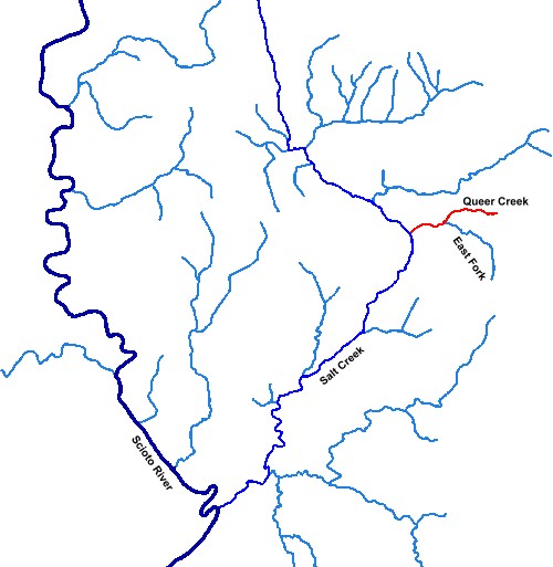
The thing is, if you look at it on a map, Queer Creek flows almost due west, just like many other streams in the area. Big Pine Creek, just to the north, flows similarly. Here’s a map showing the drainage pattern with Queer Creek, Salt Creek, and the Scioto River (which flows south towards the Ohio):
Needless to say, I suspect that the story about the name “Queer Creek” has been altered or forgotten over time, and what we are left with is a distorted myth about it.
Just what is queer about Queer Creek? Remember when we talked about What’s Wrong with Salt Creek?. I think that’s actually the source of the name. Here again is that topographic color map of Salt Creek:
Queer Creek joins Salt Creek just before Salt Creek plunges into that gorge, the gorge that was formed from the old glacial lake that plugged up the original outlet for Salt Creek. If you are standing along Queer Creek in that area for the first time and looking at the topography (as early explorers and settlers would have done), you would expect the stream flow to continue west down the obvious valley. Instead, it goes the wrong way and turns left (south) instead.
Now that really is queer.


Leave a comment